


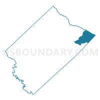
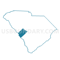
Perry Voting District, Aiken County, South Carolina
About
Outline

Summary
| Unique Area Identifier | 664956 |
| Name | Perry Voting District |
| County | Aiken County |
| State | South Carolina |
| Area (square miles) | 39.59 |
| Land Area (square miles) | 39.29 |
| Water Area (square miles) | 0.30 |
| % of Land Area | 99.25 |
| % of Water Area | 0.75 |
| Latitude of the Internal Point | 33.63315810 |
| Longtitude of the Internal Point | -81.27321170 |
Maps

Graphs
Select a template below for downloading or customizing gragh for Perry Voting District, Aiken County, South Carolina


Neighbors
Neighoring Voting District (by Name) Neighboring Voting District on the Map
- 023 Voting District, Lexington County, SC
- 083 Voting District, Lexington County, SC
- North 1 Voting District, Orangeburg County, SC
- Salley Voting District, Aiken County, SC
- Springfield Voting District, Orangeburg County, SC
- Wagner Voting District, Aiken County, SC
Top 10 Neighboring County Subdivision (by Population) Neighboring County Subdivision on the Map
- Pelion CCD, Lexington County, SC (24,185)
- Swansea CCD, Lexington County, SC (16,186)
- Wagener CCD, Aiken County, SC (4,815)
- Salley CCD, Aiken County, SC (2,589)
- Springfield CCD, Orangeburg County, SC (2,139)
Top 10 Neighboring Place (by Population) Neighboring Place on the Map
Top 10 Neighboring Unified School District (by Population) Neighboring Unified School District on the Map
- Aiken County School District, SC (162,758)
- Lexington School District 1, SC (121,030)
- Orangeburg School District 4, SC (20,430)
- Lexington School District 4, SC (18,306)
Top 10 Neighboring State Legislative District Lower Chamber (by Population) Neighboring State Legislative District Lower Chamber on the Map
- State House District 96, SC (41,272)
- State House District 86, SC (39,715)
- State House District 93, SC (32,607)
- State House District 90, SC (32,339)
Top 10 Neighboring State Legislative District Upper Chamber (by Population) Neighboring State Legislative District Upper Chamber on the Map
Top 10 Neighboring 111th Congressional District (by Population) Neighboring 111th Congressional District on the Map
Top 10 Neighboring Census Tract (by Population) Neighboring Census Tract on the Map
- Census Tract 217, Aiken County, SC (4,815)
- Census Tract 209.03, Lexington County, SC (4,679)
- Census Tract 118, Orangeburg County, SC (4,607)
- Census Tract 208.03, Lexington County, SC (3,490)
- Census Tract 209.04, Lexington County, SC (3,184)
- Census Tract 218, Aiken County, SC (2,589)
Top 10 Neighboring 5-Digit ZIP Code Tabulation Area (by Population) Neighboring 5-Digit ZIP Code Tabulation Area on the Map
- 29160, SC (8,255)
- 29123, SC (7,617)
- 29112, SC (4,712)
- 29164, SC (4,690)
- 29107, SC (3,166)
- 29137, SC (2,539)